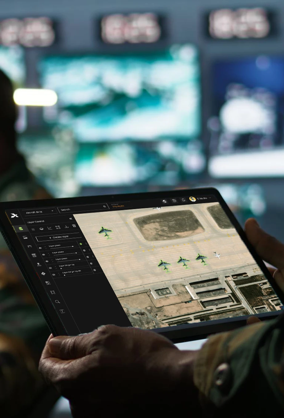
Deploy military-grade AI to identify, classify, and track strategic assets and potential threats across monitored zones.
Original Video
Result Video
Multi-Spectrum Analysis
Identify objects using thermal, infrared, and radar imagery.
Movement Tracking
Detect patterns, troop movements, and vehicle routes.
Automated Threat Validation
Use AI-powered anomaly detection to reduce false positives.
Behavioral Prediction
Recognize potential threats before they escalate.
002 -- INTELLIGENT CHANGE DETECTION
Leverage AI-powered analysis for automated monitoring of high-value installations and critical infrastructure.
4/2024
6/2024
Activity Monitoring
Detect new constructions, perimeter breaches, or troop deployments.
Multi-Source Data Fusion
Combine satellite, drone, CCTV, and ground sensor data for higher monitoring frequency.
Historical Comparison
Conduct multi-temporal analyses for long-term trend assessments.
Automated Alerts
Receive notifications on suspicious activities or environmental changes.
003 -- DRONE DRAPING
Overlay real-time or recorded drone imagery onto 3D terrain models or maps for heightened situational awareness.
Geospatial Contextualization
Blend live drone footage with geographic layers.
Historical Correlation
Compare current drone feeds with archived data to identify changes quickly.
Dynamic Targeting
Track aircraft, vehicles, or personnel in secured zones.
Time-Series Analysis
Review changes over time for mission debriefs and intelligence gathering.
004 -- CCTV AND GROUND CAMERAS
Unify on-site video feeds with other intelligence sources for a comprehensive viewpoint.
Real-Time Video Analytics
Detect unauthorized access, suspicious movements, or perimeter intrusions.
Automated Summaries
Rapidly sift through hours of footage for key events.
Integrated Dashboards
Combine CCTV feeds with satellite, drone, and sensor data in one single pane of glass.
Scalability
Add or remove camera endpoints as mission needs evolve.
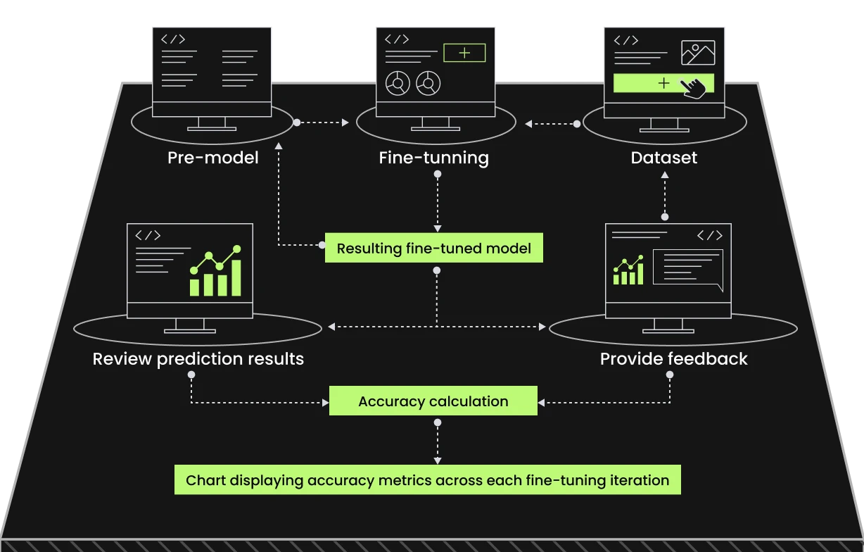
Tailored AI for Your Mission
Optimize models for specific geographic or operational contexts—no specialized data science skills needed.
Multi-Spectrum Analysis
Identify objects using thermal, infrared, and radar imagery.
Movement Tracking
Detect patterns, troop movements, and vehicle routes.
Enhance Operational Mapping with Smart Annotations
/0.1 --
Interactive Drawing Tools
Add arrows, polygons, and lines to denote routes, perimeters, or no-go zones.
Visualize troop or supply paths with directional annotations.
/0.2 --
Custom Text Annotations
Label sites of interest, threats, or mission assets with easy-to-read text overlays.
Use flexible font styles and colors for clarity and urgency.
/0.3 --
Layer-Specific Annotations
Dynamically scale processing power to handle larger datasets or increased demand during high-stakes scenarios.
Works in both cloud-based environments for flexibility and on-premises systems for secure operations.
/0.4 --
Seamless Integration
Combine annotations with AI outputs like route planning or site suitability analyses.
Align visual notes with machine-driven insights for enhanced validation.
/0.5 --
Quick Editing & Updates
Rapidly adjust or remove annotations as mission parameters shift.
Maintain an audit trail of annotation history.
Actionable Alerts to Stay Ahead of Threats
Detect potential threats or anomalies during site monitoring. Stay informed with automated notifications that prompt immediate decisions.
CUSTOMIZABLE THRESHOLDS
Configure alert levels for specific activities or changes.
INSTANT NOTIFICATIONS
Receive alerts via email, SMS, or system dashboards.
INCIDENT REPORTING
Generate auto-reports complete with geospatial data for thorough reviews.
Real-Time Intelligence for Site Security with Edge AI
Deploy AI models on drones, ground sensors, or surveillance systems for immediate analysis—even in Disconnected, Intermittent, Limited-Bandwidth (DDIL) environments.
ON-DEVICE PROCESSING
Detect anomalies and validate outputs on the spot.
REDUCED LATENCY
Cut down on lag by analyzing data directly at the source.
CONTINUOUS LEARNING
Improve models in real-time, based on immediate feedback.
Explore Edge AI
E
n
t
e
r
p
r
i
s
e
-
R
e
a
d
y
P
r
o
d
u
c
t
s
t
h
a
t
Scale with Your Operations
Scale with Your Operations
Scroll to explore
Secure, Scalable, and Modern Cloud Solutions
Optimized for resilience, scalability, and high availability, Aetosky ensures operations are supported on trusted and compliant systems.
Hybrid Cloud Deployment:
Combine private cloud for handling sensitive workloads with public cloud scalability for non-sensitive operations.
Scalable Performance:
Elastic cloud architectures to dynamically allocate resources based on operational demands.
Discover how Aetosky can modernize your GEOINT operations
We use cookies to improve your experience, analyze site performance, and personalize content and ads. You can accept all cookies or customize your preferences to control which cookies are used.
We use cookies categorized as follows. You can enable or disable these based on your preference. Please note that disabling some cookies may impact site functionality.