Products/Aetos Core

Enterprise-Grade
Architecture Solution

A robust, secure, and scalable architecture engineered for mission-critical geospatial operations.

What is Aetos Core?

Aetos Core integrates data, workflows, AI, and tools, ensuring interoperability and resilience. It empowers efficient, mission-critical operations in complex environments.

Cloud-native,
microservices architecture

Scalable, reliable, and adaptable to meet mission-critical demands, ensuring long-term operational resilience.

Engineered for secure operations

Complies with global standards like NATO and FIPS, leveraging encryption and multi-factor authentication to safeguard data and ensure continuity.

Powering Enterprise-
Grade Geospatial Solutions

PRODUCTS LAYER
A Versatile Suite of Geospatial Intelligence Tools
AI analytics, data infrastructure, and visualiation.
No-code tools to build, enhance, and deploy AI models. These platforms ensure immediate value from day one, enabling users to manage vast geospatial datasets, perform time-series analysis, and create intuitive, shareable visualizations without requiring technical expertise.
Data ingestion and processing to insights.
Streamlines the entire geospatial intelligence workflow, from sourcing raw data through archive or tasking, to processing, managing, and transforming it into actionable insights for operational efficiency and seamless dissemination.
Flexible mobile app and integrations.
Designed for both on-the-go and stationary use, supporting field agents with mobile apps while enabling seamless integration into existing enterprise systems.
PRESENTATION LAYER
Brings together all Aetosky products into a unified, cohesive system for end-users.
Ready for web and mobile platforms.
Accessible through user-friendly interfaces optimized for both web browsers and mobile devices, ensuring uninterrupted operations in diverse environments.
Integrates seamlessly with third-party systems.
Built on open standards and APIs to connect with external GIS platforms, command-and-control systems, and proprietary tools, enhancing interoperability.
Developer tools and SDKs for custom workflows.
Equips developers with robust tools and SDKs to tailor geospatial workflows, integrate bespoke features, or create entirely new capabilities within the ecosystem.
SECURITY & GOVERNENCE LAYER
Implements strict compliance and access control across the Aetosky ecosystem.
Enterprise-grade encryption and security.
Utilizes AES-256 encryption and multi-factor authentication to safeguard sensitive data, meeting the highest security standards for defense and civil applications.
Comprehensive data governance tools.
Enables organizations to define, enforce, and monitor data policies, ensuring compliance with internal and external regulations while maintaining data integrity.
Regulatory compliance (FIPS, GDPR, ITAR).
Designed to meet global and regional compliance requirements, including ITAR for defense exports, GDPR for data privacy, and FIPS for cryptographic security.
SERVICES LAYER
Offers advanced tools for data ingestion, AI, analysis, and visualization.
Data management and processing.
Handles ingestion, transformation, and organization of geospatial data, ensuring it is ready for analysis or integration across workflows.
AI and machine learning tools.
Leverages pre-trained and custom AI models to extract patterns, predict trends, and automate geospatial tasks without requiring extensive technical expertise.
Workflow automation.
Streamlines repetitive processes like data ingestion, processing, and analysis, reducing human effort and speeding up intelligence delivery.
Advanced analytics capabilities.
Provides tools for in-depth geospatial analysis, enabling users to derive insights such as change detection, terrain analysis, and threat modeling.
Visualization services.
Transforms complex geospatial data into intuitive visual formats, such as 3D maps and interactive dashboards, to support strategic decision-making.
ORCHESTRATION LAYER
Centralizes system performance and resource allocation to ensure smooth operations.
Scalable infrastructure for dynamic workloads.
Dynamically allocates resources to handle varying workloads, ensuring smooth operations during peak demands or large-scale data processing tasks.
Real-time system monitoring & management.
Offers a centralized dashboard for tracking system performance, identifying bottlenecks, and proactively resolving issues before they impact operations.
Disaster recovery mechanisms for continuity.
Ensures critical systems and data are backed up and recoverable, maintaining operations even during unforeseen disruptions or system failures.
Performance optimization for deployments.
Transforms complex geospatial data into intuitive visual formats, such as 3D maps and interactive dashboards, to support strategic decision-making.
Built for Enterprises.
Trusted by Defense.
SCALABILITY
Auto-scaling microservices architecture.
SECURITY
FIPS-compliant encryption and RBAC.
INTEGRATION
Standards-based APIs and OGC compliance.
HIGH AVAILABILITY
99% uptime SLA with global redundancy.

Future-Ready Architecture
for Innovation

API Documentation
Developer SDKs
Integrations & Compliance
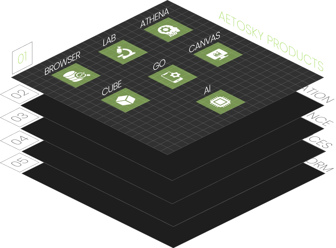
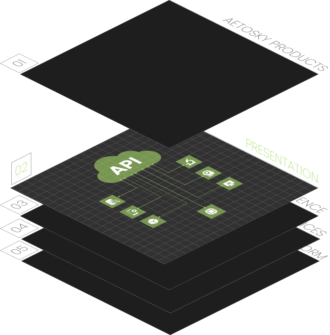
001 -- API DOCUMENTATION
Unlock Seamless Integration with RESTful APIs
REST APIs:
Aetos Core offers REST APIs designed for flexibility and scalability, allowing seamless interaction with your applications and workflows.
OGC standards:
Fully compliant with OGC standards (WMS, WFS, WCS, CSW) to ensure interoperability with leading geospatial systems.
Developer-Friendly Examples:
Access sample API calls and pre-built workflows to accelerate integration.
Explore the API Documentation
002 -- DEVELOPER SDKs
Streamline Development with Python SDK
Python:
SDKs are available for Python, enabling rapid development across diverse environments.
Step-by-Step Tutorials:
Get started quickly with comprehensive guides and example use cases tailored to your needs.
CI/CD pipelines:
Built for integration with CI/CD pipelines to ensure continuous deployment of scalable solutions.
Download SDKs and Tutorials
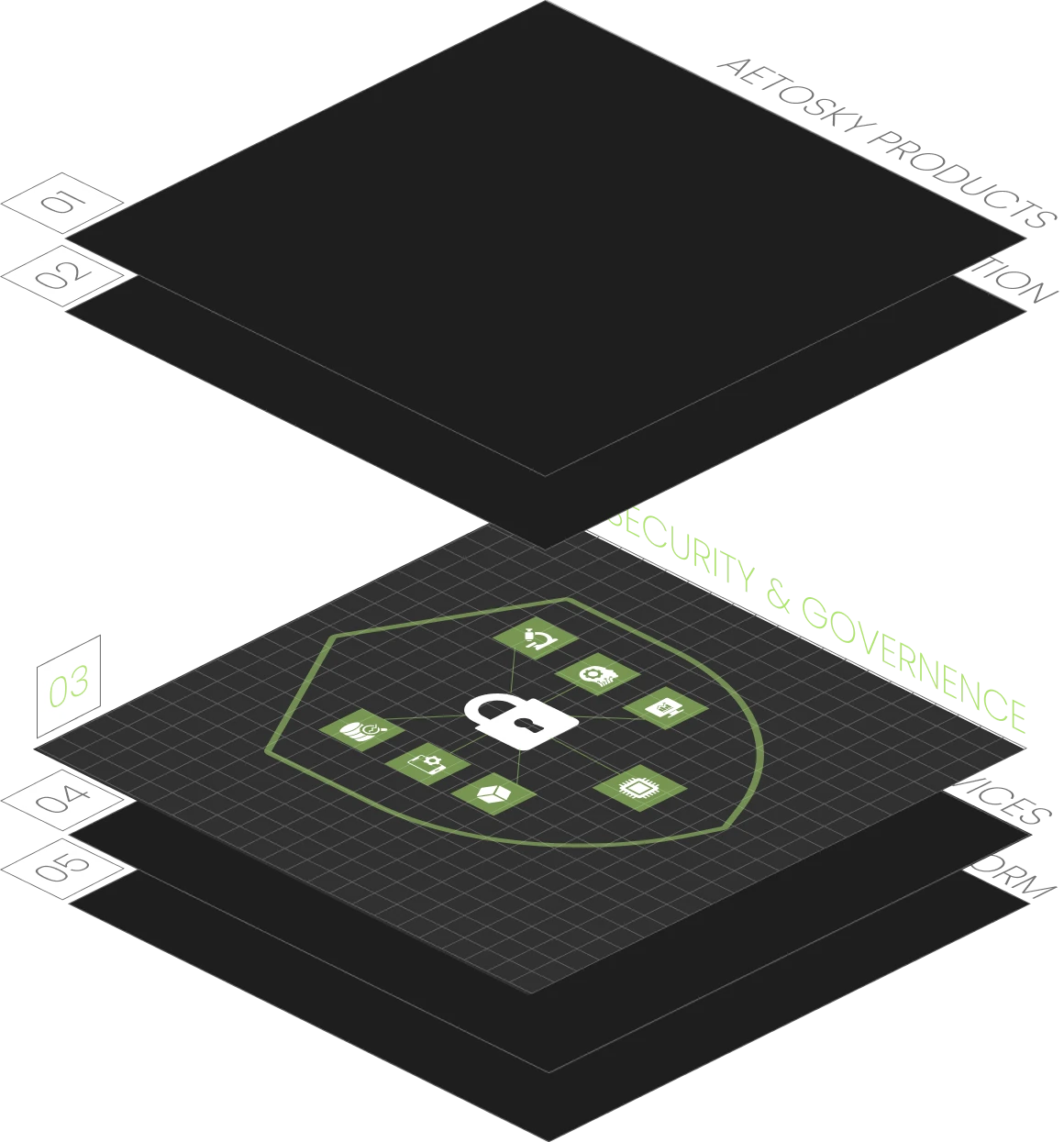
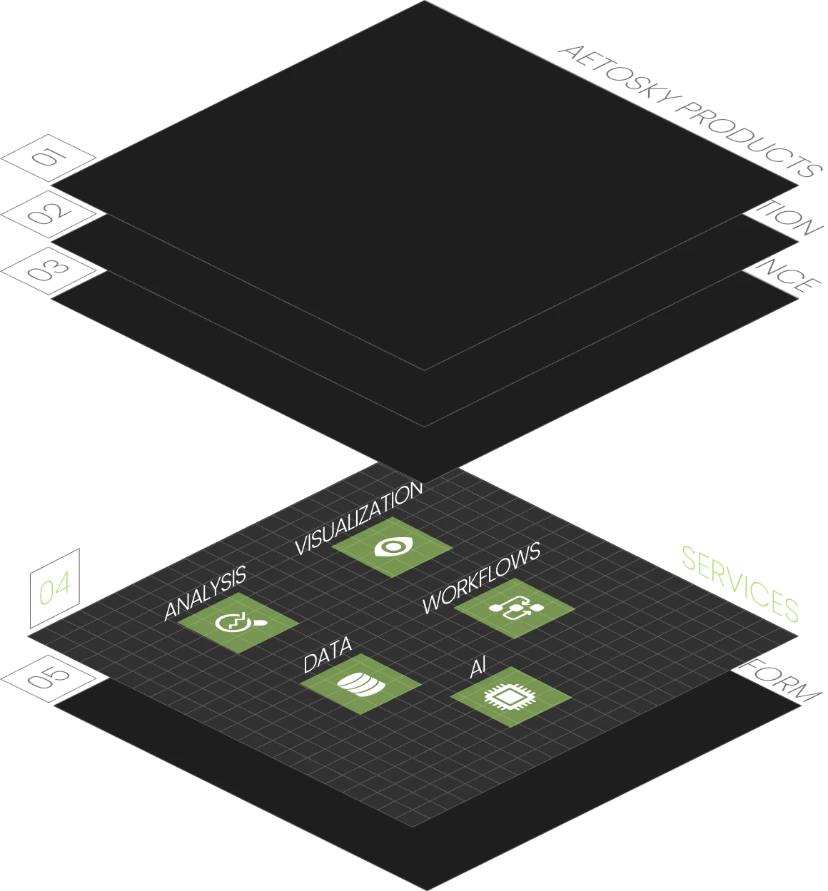
003 -- SUPPORTED INTEGRATIONS & COMPLIANCE
Built for Enterprise Ecosystems
ERP, CRM, and BI platforms:
Integrate with leading ERP, CRM, and BI platforms such as SAP, Salesforce, and Tableau for end-to-end geospatial workflows.
Esri ArcGIS, QGIS:
Native support for integration with tools like Esri ArcGIS, QGIS, and other industry-leading platforms.
Enterprise-Grade Compliance
FIPS, ITAR, and OGC:
Aetos Core meets rigorous standards including FIPS, ITAR, and OGC, ensuring robust security and interoperability for defense and government applications.
Ensure regulatory compliance:
Ensure regulatory compliance while maintaining system flexibility and scalability.
Learn About Compliance Standards
Discover how Aetosky can
modernize your GEOINT
operations
Request Demo