Defense & Intelligence

Secure Borders with Real-Time Monitoring & Intelligence

Enhance situational awareness and secure expansive borders using AI-powered solutions engineered for modern defense operations.
Move Beyond Traditional Border Surveillance

Static systems and outdated workflows cannot match the scale and complexity of today’s border challenges.

Limitations of Legacy Border Solutions

DELAYED INTELLIGENCE
Slow, infrequent data updates fail to capture dynamic activities.
LIMITED INTERGRATION
Inability to fuse multi-source intelligence for comprehensive monitoring.
MANUAL ANALYSIS OVERLOAD
Lack of automation creates delays in threat detection.
With Aetosky
Defense Teams Can
FUSE MULTI-SOURCE DATA
Integrate open-source and proprietary satellite imagery, UAV feeds, and ground sensors for near-real-time insights.
DETECT AND RESPOND FASTER
Use AI-driven anomaly detection to pinpoint unauthorized activities promptly.
OPTIMIZE TIP-AND-CUE OPERATIONS
Automate initial sweeps with open-source satellite imagery to flag potential hotspots, then allocate higher-resolution or drone resources for detailed follow-up.
ADAPT TO DYNAMIC THREATS
Stay proactive with automated alerts and evolving AI models that adapt to real-time changes along border zones.

Key Capabilities

Topography & Line-of-Sight Analysis
Custom AI Model Localization
AI-Powered Change Detection
Multi-Source Data Fusion
Field Integration with Aetos GO
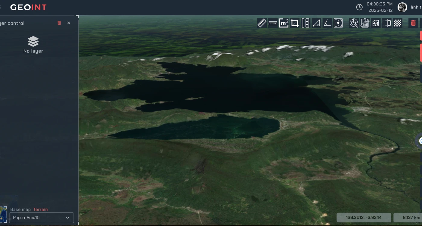
001 -- TOPOGRAPHY AND LINE-OF-SIGHT ANALYSIS
Optimize surveillance coverage and identify blind spots across complex terrains.
Line-of-Sight (LOS) Analysis
Identify optimal surveillance posts and detect blind zones.
3D Terrain Models
Generate high-accuracy DEMs (Digital Elevation Models) for realistic border terrain planning.
Contour & Slope Mapping
Simplify patrol route planning and resource deployment across challenging landscapes.
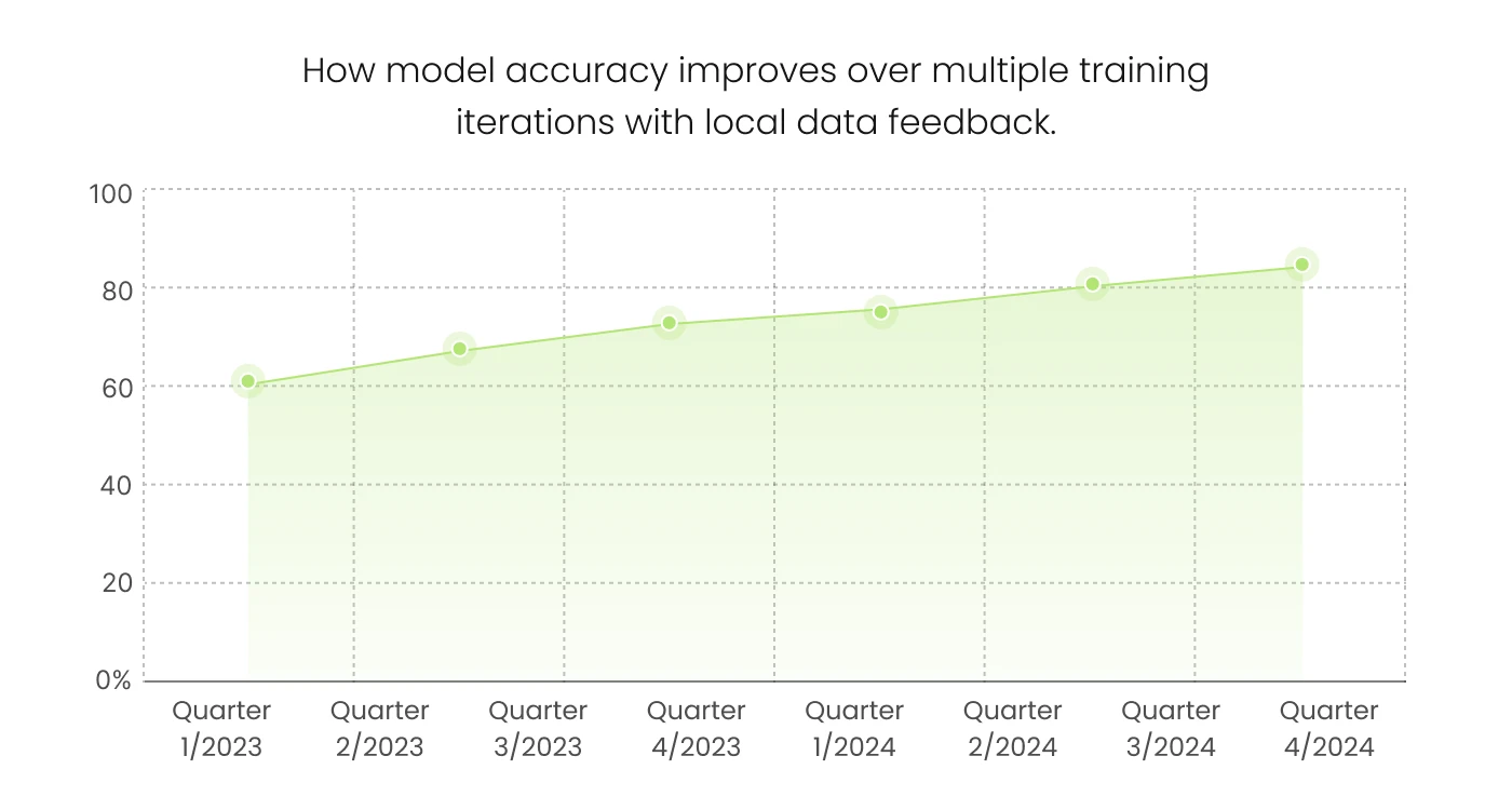
002 -- LOCALIZED AI MODEL CUSTOMIZATION
Tailor AI models to regional challenges and intelligence requirements without in-house data science expertise.
Region-Specific Training
Incorporate local ground truth data for higher detection accuracy.
Human-in-the-Loop Learning
Field teams or analysts validate AI results, feeding back to constantly refine models.
003 -- AI-POWERED CHANGE DETECTION
Automatically spot changes and anomalies along border zones using multi-temporal analysis—ranging from open-source to high-resolution satellite data.
Classify & Prioritize Changes
Identify unauthorized construction, smuggling routes, and troop movements; rank them by severity
Automated Ingestion
Continuously pull open-source imagery (Sentinel, Landsat, etc.) to refresh basemaps for broad-area sweeps.
Targeted Tasking for High-Res Data
Tip-and-cue mechanism triggers one-click high-resolution or drone requests where anomalies are detected, reducing unnecessary data acquisition costs..
Near-Real-Time Alerts
Get notifications for perimeter breaches or suspicious activity flagged by AI.
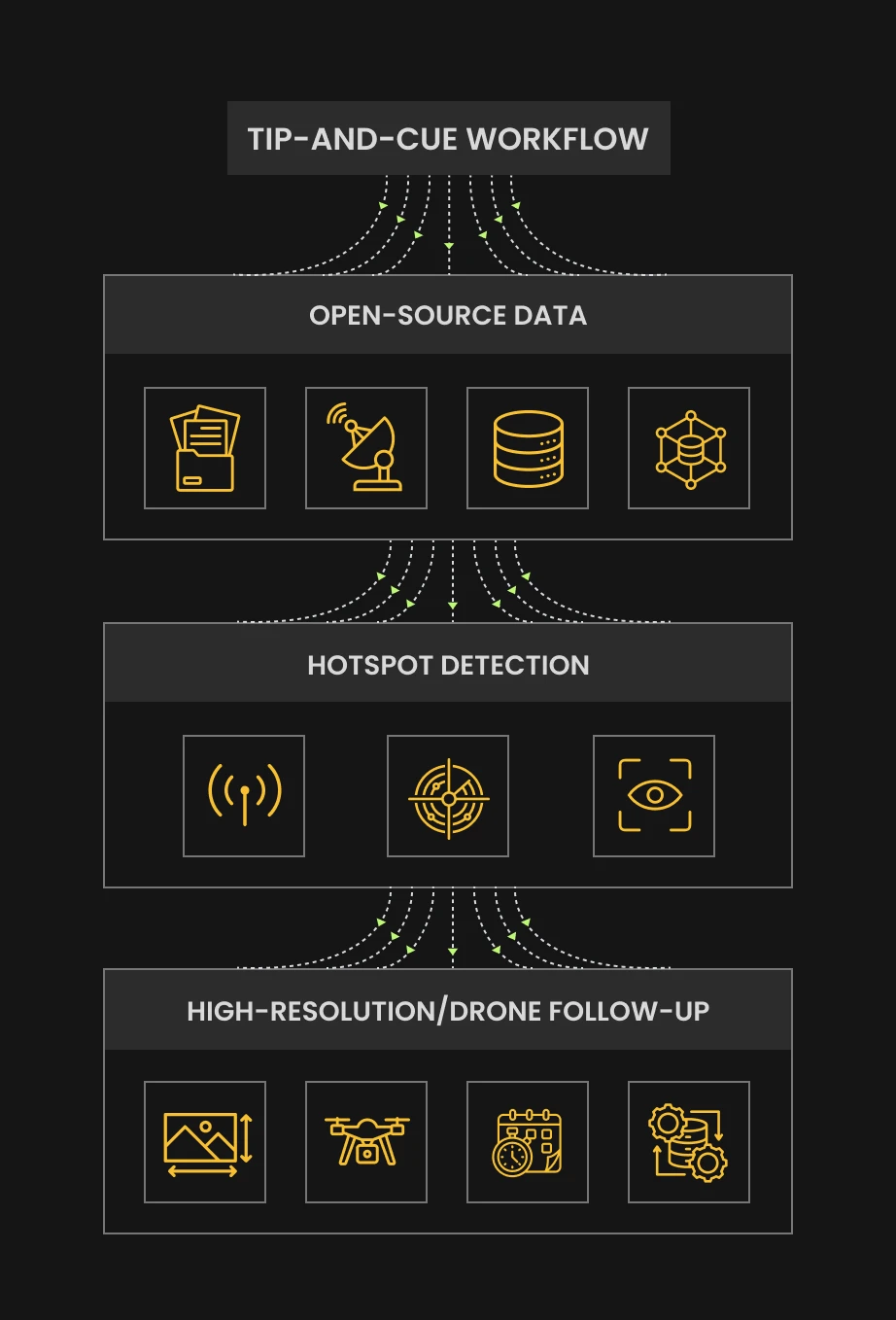
004 -- MULTI-SOURCE DATA FUSION FOR ENHANCED MONITORING CADENCE
Combine insights from open-source satellite, commercial high-resolution imagery, UAV feeds, and ground sensors to maintain an up-to-date view of border zones.
Tip-and-Cue Mechanism
Conduct wide scans with open-source, then cue high-resolution resources for deeper investigation.
Flexible Data Streams
Seamlessly integrate IMINT, SIGINT, and sensor data into a single operational interface.
Historical Insights & Trend Analysis
Overlay past observations to spot patterns and improve threat prediction.
Automated Workflows
Schedule data ingestion at intervals, balancing cost-effectiveness with high-frequency updates.
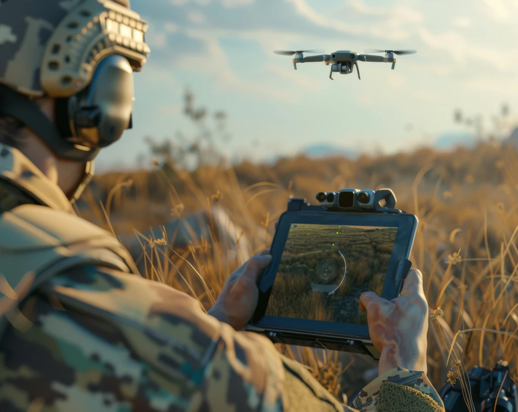
005 -- FIELD INTERGRATION WITH AETOS GO
Extend capabilities beyond the command center to ground operations.
Task & Validate
Deploy field teams to investigate anomalies flagged by AI for real-world confirmation.
Rapid Reporting
Submit on-the-ground observations and photos in near-real time to refine AI feedback loops.
Centralized Intelligence Refinement
Sync field data with your command center for automated model updates, enhancing future detections.

Enhance Operational Mapping
with Smart Annotations

/0.1 --
Interactive Drawing Tools
Add arrows, polygons, and lines to denote routes, perimeters, or no-go zones.
Visualize troop or supply paths with directional annotations.
/0.2 --
Custom Text Annotations
Label sites of interest, threats, or mission assets with easy-to-read text overlays.
Use flexible font styles and colors for clarity and urgency.
/0.3 --
Layer-Specific Annotations
Dynamically scale processing power to handle larger datasets or increased demand during high-stakes scenarios.
Works in both cloud-based environments for flexibility and on-premises systems for secure operations.
/0.4 --
Seamless Integration
Combine annotations with AI outputs like route planning or site suitability analyses.
Align visual notes with machine-driven insights for enhanced validation.
/0.5 --
Quick Editing & Updates
Rapidly adjust or remove annotations as mission parameters shift.
Maintain an audit trail of annotation history.

Receive Instant Alerts
for Threats and Anomalies

Ensure faster decision-making with automated alerts and notifications.
CUSTOMIZABLE ALERTS
Set thresholds for activity detection or perimeter breaches, ranging from minor to critical.
NEAR-REAL-TIME NOTIFICATIONS
Deliver alerts to dashboards, email, or SMS so teams can respond swiftly.
INCIDENT REPORTING
Generate automated reports with geospatial intelligence for leadership review or follow-up action.

Extend Monitoring
with Edge AI for
Border Zones

Deploy AI models on drones, ground sensors, and other edge devices to analyze data in remote or disconnected environments.
ON-SITE ANALYSIS
Run AI on satellite, drone, or sensor data locally to detect anomalies in real time.
REDUCED BANDWIDTH DEPENDENCE
Process data at the tactical edge, uploading only critical insights.
CONTINUOUS MODEL REFINEMENT
Local insights feed back to the central system for iterative training and improvement.
E
n
t
e
r
p
r
i
s
e
 
-
 
R
e
a
d
y
 
P
r
o
d
u
c
t
s
 
t
h
a
t
Scale with Your Operations
Scroll to explore

Secure, Scalable,
and Modern Cloud Solutions

Optimized for resilience, scalability, and high availability, Aetosky ensures operations are supported on trusted and compliant systems.
creodias
azure
aws
gg-cloud
Hybrid Cloud Deployment:
Combine private cloud for handling sensitive workloads with public cloud scalability for non-sensitive operations.
Scalable Performance:
Elastic cloud architectures to dynamically allocate resources based on operational demands.
Discover how Aetosky can
modernize your GEOINT
operations
Request Demo